FAA INFORMATION EFFECTIVE 18 APRIL 2024
Location
| FAA Identifier: | 62C |
| Lat/Long: | 42-48-40.9999N 088-05-38.7216W
42-48.683332N 088-05.645360W
42.8113889,-88.0940893
(estimated) |
| Elevation: | 784 ft. / 239 m (estimated) |
| Variation: | 01W (1985) |
| From city: | 7 miles NW of FRANKSVILLE, WI |
| Time zone: | UTC -5 (UTC -6 during Standard Time) |
| Zip code: | 53126 |
Airport Operations
| Airport use: | Open to the public |
| Activation date: | 03/1962 |
| Control tower: | no |
| ARTCC: | CHICAGO CENTER |
| FSS: | GREEN BAY FLIGHT SERVICE STATION |
| NOTAMs facility: | GRB (NOTAM-D service available) |
| Attendance: | UNATNDD |
| Wind indicator: | yes |
| Segmented circle: | no |
| Lights: | ACTVT LIRL RY 01/19 - CTAF. |
Airport Communications
| CTAF: | 122.9 |
| WX AWOS-3 at BUU (12 nm SW): | 125.275 (262-757-0907) |
| WX ASOS at MKE (12 nm NE): | 126.4 (414-489-2168) |
| WX AWOS-3PT at 57C (12 nm W): | 118.125 (262-642-1845) |
| WX ASOS at RAC (13 nm E): | 121.425 (262-635-0959) |
| WX ASOS at ENW (15 nm SE): | PHONE 262-652-7730 |
| WX AWOS-3 at UES (15 nm NW): | 118.875 (262-521-5226) |
| WX AWOS-3 at MWC (18 nm N): | PHONE 414-461-2954 |
Nearby radio navigation aids
| VOR radial/distance | | VOR name | | Freq | | Var |
|---|
| BAEr153/20.1 | | BADGER VOR/DME | | 116.40 | | 02E |
| OBKr352/36.0 | | NORTHBROOK VOR/DME | | 113.00 | | 02W |
| BJBr179/(36.7) | | WEST BEND VOR | | 109.80 | | 01W |
| NDB name | | Hdg/Dist | | Freq | | Var | | ID |
|---|
| ROCK RIVER | | 129/35.2 | | 371 | | 01W | | RYV | .-. -.-- ...- |
Airport Services
| Parking: | tiedowns |
| Airframe service: | NONE |
| Powerplant service: | NONE |
| Bottled oxygen: | NONE |
| Bulk oxygen: | NONE |
Runway Information
Runway 1/19
| Dimensions: | 2381 x 70 ft. / 726 x 21 m |
| Surface: | turf, in good condition |
| Runway edge lights: | non-standard
RY 01/19 NSTD LIRL HAS 2 PAIRS OF LGTS EACH END. |
| RUNWAY 1 | | RUNWAY 19 |
| Latitude: | 42-48.511380N | | 42-48.897180N |
| Longitude: | 088-05.703110W | | 088-05.608550W |
| Elevation: | 784.0 ft. | | 782.0 ft. |
| Traffic pattern: | left | | left |
| Runway heading: | 011 magnetic, 010 true | | 191 magnetic, 190 true |
| Obstructions: | 20 ft. brush, 55 ft. left of centerline, 1:1 slope to clear | | 20 ft. brush, 70 ft. right of centerline, 1:1 slope to clear |
Runway 18/36
| Dimensions: | 1239 x 80 ft. / 378 x 24 m |
| Surface: | turf, in fair condition
ROUGH & UNDULATING ROLLING TERRAIN. |
| RUNWAY 18 | | RUNWAY 36 |
| Latitude: | 42-48.745020N | | 42-48.541130N |
| Longitude: | 088-05.621220W | | 088-05.629260W |
| Elevation: | 781.0 ft. | | 779.0 ft. |
| Traffic pattern: | left | | left |
| Runway heading: | 183 magnetic, 182 true | | 003 magnetic, 002 true |
| Obstructions: | 10 ft. brush, 8 ft. from runway, 50 ft. left of centerline, 1:1 slope to clear | | 20 ft. brush, 70 ft. from runway, 100 ft. right of centerline, 3:1 slope to clear |
Airport Ownership and Management from official FAA records
| Ownership: | Privately-owned |
| Owner: | DAVID GUNTLY
22031 SIX MILE RD
FRANKSVILLE, WI 53126
Phone 414-587-1528 |
| Manager: | DAVID GUNTLY
22031 SIX MILE RD
FRANKSVILLE, WI 53126
Phone 414-587-1528
EMAIL ADDRESS: CRAZYBIPLANE@GMAIL.COM (ALL LOWER CASE) |
Airport Operational Statistics
| Aircraft based on the field: | | 34 | | Single engine airplanes: | | 30 | | Helicopters: | | 1 | | Ultralights: | | 3 |
| |  | |
| Aircraft operations: avg 128/week * | | 78% | local general aviation | | 22% | transient general aviation | | * for 12-month period ending 02 June 2022 | |
Additional Remarks
| - | RY 18 & 19 GND DROPS OFF RAPIDLY AT 'S' END. |
| - | FOR CD CTC CHICAGO ARTCC AT 630-906-8921. |
Instrument Procedures
There are no published instrument procedures at 62C.
Some nearby airports with instrument procedures:
KBUU - Burlington Municipal Airport (12 nm SW)
KMKE - General Mitchell International Airport (12 nm NE)
57C - East Troy Municipal Airport (12 nm W)
KRAC - Batten International Airport (13 nm E)
KENW - Kenosha Regional Airport (15 nm SE)
KUES - Waukesha County Airport (15 nm NW)
C02 - Grand Geneva Resort Airport (18 nm SW)
KMWC - Lawrence J Timmerman Airport (18 nm N)
|
|

Road maps at:
MapQuest
Bing
Google
| Aerial photo |
|---|
WARNING: Photo may not be current or correct
 Photo by Amy Gesch
Photo taken 17-Oct-2005
Photo by Amy Gesch
Photo taken 17-Oct-2005
Do you have a better or more recent aerial photo of Cindy Guntly Memorial Airport that you would like to share? If so, please send us your photo.
|
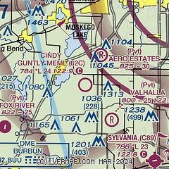
| Sectional chart |
|---|
|
| Airport distance calculator |
|---|
|
|
| Sunrise and sunset |
|---|
|
Times for 28-Apr-2024
| | Local
(UTC-5) | | Zulu
(UTC) |
|---|
| Morning civil twilight | | 05:20 | | 10:20 |
| Sunrise | | 05:50 | | 10:50 |
| Sunset | | 19:49 | | 00:49 |
| Evening civil twilight | | 20:20 | | 01:20 |
|
| Current date and time |
|---|
| Zulu (UTC) | 28-Apr-2024 19:50:52 |
|---|
| Local (UTC-5) | 28-Apr-2024 14:50:52 |
|---|
|
| METAR |
|---|
KBUU
12nm SW | 281935Z AUTO 05013G16KT 10SM OVC004 08/08 A2987 RMK AO2 T00800075 PWINO
|
KMKE
12nm NE | 281852Z 02018G25KT 2SM BR OVC004 06/04 A2994 RMK AO2 PK WND 01029/1753 SFC VIS 4 RAB18E49 SLP139 P0001 T00610044
|
K57C
12nm W | 281935Z AUTO 07014G20KT 10SM OVC004 07/07 A2986 RMK AO2 T00660066
|
KUES
12nm N | 281845Z 05013G21KT 1 1/2SM -RA BR OVC004 06/06 A2993
|
KRAC
13nm E | 281926Z AUTO 02016KT 1SM BR OVC002 07/06 A2993 RMK AO2 T00670056 $
|
KENW
15nm SE | 281941Z 06010KT 1SM BR OVC003 10/08 A2988 RMK AO2 T01000078
|
KMWC
19nm N | 281905Z 05013G20KT 3SM -RA OVC004 06/05 A2996
|
|
| TAF |
|---|
KMKE
12nm NE | 281745Z 2818/2924 02014G21KT 6SM -SHRA BR OVC007 FM282000 03010KT 3SM BR VCSH OVC003 FM290000 07005KT 5SM BR VCSH OVC014 FM290200 VRB04KT 6SM BR VCSH OVC006 FM290600 18007KT 3SM -SHRA BR OVC003 FM291400 21010KT P6SM BKN010
|
KUES
12nm N | 281745Z 2818/2918 06012KT 5SM -SHRA BR OVC007 TEMPO 2819/2823 BKN005 FM282300 09007KT 4SM -SHRA BR OVC007 FM290300 11005KT 6SM -SHRA BR OVC005 FM290600 17009KT 3SM SHRA BR OVC003 FM291400 21011KT P6SM BKN007
|
KENW
15nm SE | 281745Z 2818/2918 04009KT 3/4SM BR VCSH OVC002 TEMPO 2818/2822 1/2SM -DZ FG FM282200 09008KT 5SM BR VCSH OVC010 FM290600 18008KT 3SM SHRA BR VCTS OVC005CB FM290900 19009KT 3SM -SHRA BR OVC008 FM291200 19009KT 3SM BR OVC023 FM291500 21012G20KT P6SM BKN015
|
|
| NOTAMs |
|---|
NOTAMs are issued by the DoD/FAA and will open in a separate window not controlled by AirNav.
|
|

